
Fire threats
In January 2016, the fire season brought some tense moments, with one group needing to be evacuated from our Retreat Centre due to fears that the fire might cut off road access into Lorinna, isolating eveyone in the valley. Smoke was also quite heavy at one stage, causing some concern. Luckily, while the road in was threatened, the township and retreat centre were not in any immediate danger at any time.
Flood: a personal report by Maria
John and I had been planning for some weeks to come to Dorje Ling in order to do a bit of upkeep work on the walking track network on the Dorje Ling property, as well as improving the new memorial area for the future scattering of ashes. The forecast was for heavy rain on the Sunday 6thJune, but we thought we could still get enough time to do a bit of work on the Saturday 5th June in the afternoon and hopefully Monday morning.
We arrived on what is the only access road into the Lorinna Valley, which is called River Road. (There used to be another access road to the north, but it has been closed by the Kentish Council for some years due to safety concerns.)
We arrived early Saturday afternoon, touched base with the caretaker, settled into our hut, and started our work, trying to get as much achieved as we could before the rain set in.
On Sunday morning we woke to very heavy rain indeed, so we lit the fire in our hut and settled in, hoping it would clear soon. However around lunch time the caretaker came down to let us know that the new mini-hydro turbine was no longer visible from the bank and quite possibly washed away. We could see from our hut that the creek which contains the system was absolutely raging.
In spite of the rain we went down to the bottom of the creek, and I was astonished to see that one of our seats, called “River Run Seat”, which was situated on a largish flat area beside the river, had been washed away. Some of the supporting rocks were just teetering on the edge.

The last of the supporting rocks for the seat
On Monday morning we were planning to leave and go back to Hobart. But before we could even start to pack, the caretaker turned up to let us know that there was a large washout near the far end of River Road. He thought it might be possible to get out with a 4WD (which we have), but that it would be best to stay another day and possibly the Council might come with a grader to fix that section. So we took stock of our supplies and realised we only had one day’s extra food. We hoped this would be enough until the road was fixed.
Later on in the day the caretaker came back down and told us that River Road was no longer an option. A section of it had just slid right down the hill into the lake, along with part of the rocky hillside above the road. The devastation was immense, meaning that there would be no quick fix and we were stuck in the Valley for some indeterminate period.
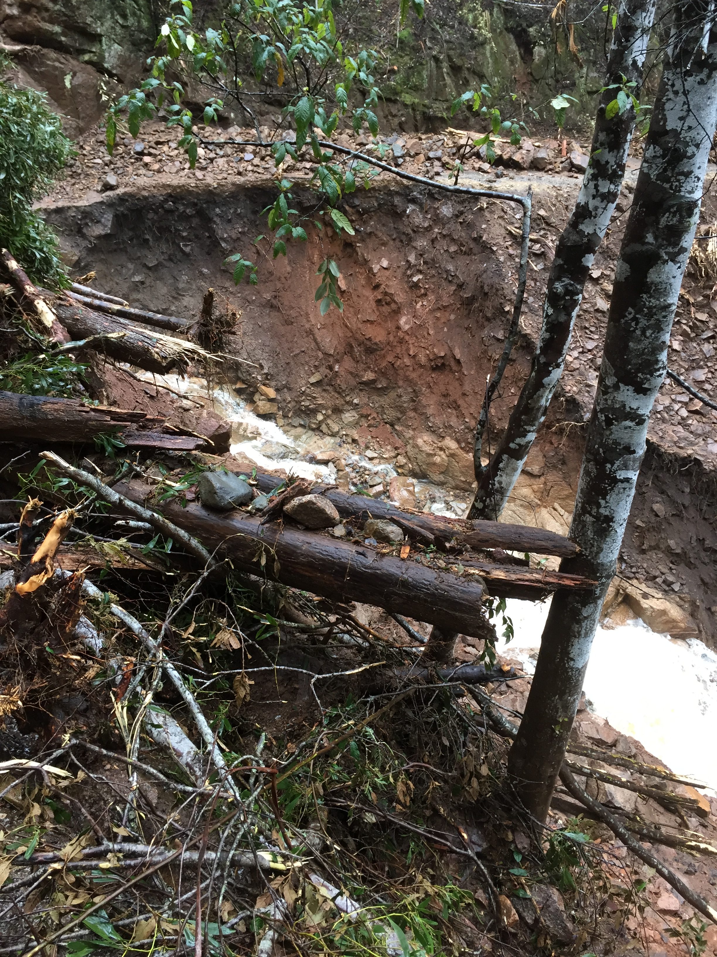
River Road, a huge chunk washed down the hill to the lake
The main bridge in the valley, the bridge over Oliver’s Creek, had also completely washed away, meaning that the small township was now cut into two.
Many things went through our heads at this point. We thought we may be able to drive out on one of the 4WD tracks out of Lorinna, and Jack promised to ask others in the Valley what the condition of Hardwick’s Road was (the most likely option). He told us he was not sure that it was driveable at all.
One worst-case scenario possibility, which we considered, was the option of walking out. We thought the shortest and best walking option would be up Hardwick’s Road. We hoped we could maybe drive part of the way up and walk the rest to a lift, and ask Jack to take the car back down to Lorinna once we could drive no further. Since food was low we were shown the larder in the property’s farmhouse and told we could use whatever food was there to tide us over until something worked out.
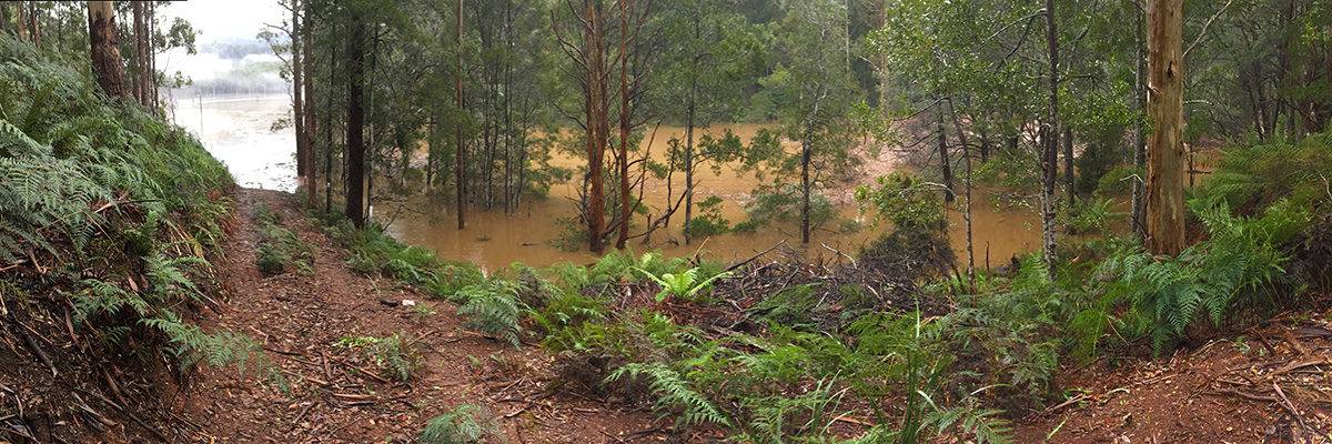
In the meantime the lake had risen quite a few metres above the usual high water mark. We went down again to check on the state of the “River Run seat” but were not even able to get down anywhere near the area, as the lower tracks were flooded by several metres. The inlet at the bottom of the creek had extended upwards to many, many metres wide, and was filled with swirling debris.

The bottom of the creek, above the junction to the lake, at the height of the flood.
Luckily the weather had improved somewhat and we spent some time on Monday doing our usual track work, and sawing up some logs that had fallen over the tracks during the storm. Later, we prepared ourselves a meal from the tinned food and potatoes in the farmhouse larder.
Meanwhile the caretaker had been busy liaising with others in the Lorinna Valley. Mobile coverage (usually poor) had completely dropped out. Most of the landlines in the valley were also out. Our property and Damien’s were the only ones with working landlines, so the caretaker was very busy relaying urgent messages between Valley residents and the outside.
He also made many enquiries about the possibility of getting John and myself out. He said Hardwick’s Road had been tried and was not an option, with vehicles attempting it getting stuck only a few metres in. Later we found that there were huge 2 metre drops further up the road. So Hardwick’s Road would only be an option if we were walking. (It’s as well we did not end up doing this as despite our best advice that Lemonthyme Road at the top was open, we found out later that it was in fact impassable, as was Olivers Road, and we would have had to choose from either walking back down the slippery steep hill to Lorinna, or walking on some 20k or more not knowing where the road was open from. There would have been no mobile coverage for us to get help.)
A second option, and the one we eventually ended up taking, was that Trevor had just been authorised to take a punt between Lorinna and the Cethana Dam on Wednesday morning, since the spillway, while still dangerous, was safe for a person of his experience using a punt. Trevor was planning to leave at 7am the following morning to be in time for his work assisting the deep sea diving school at Cethana Dam.
Roger had kindly offered to come all of the way from Hobart with his car to pick us up. (See Roger’s report below)
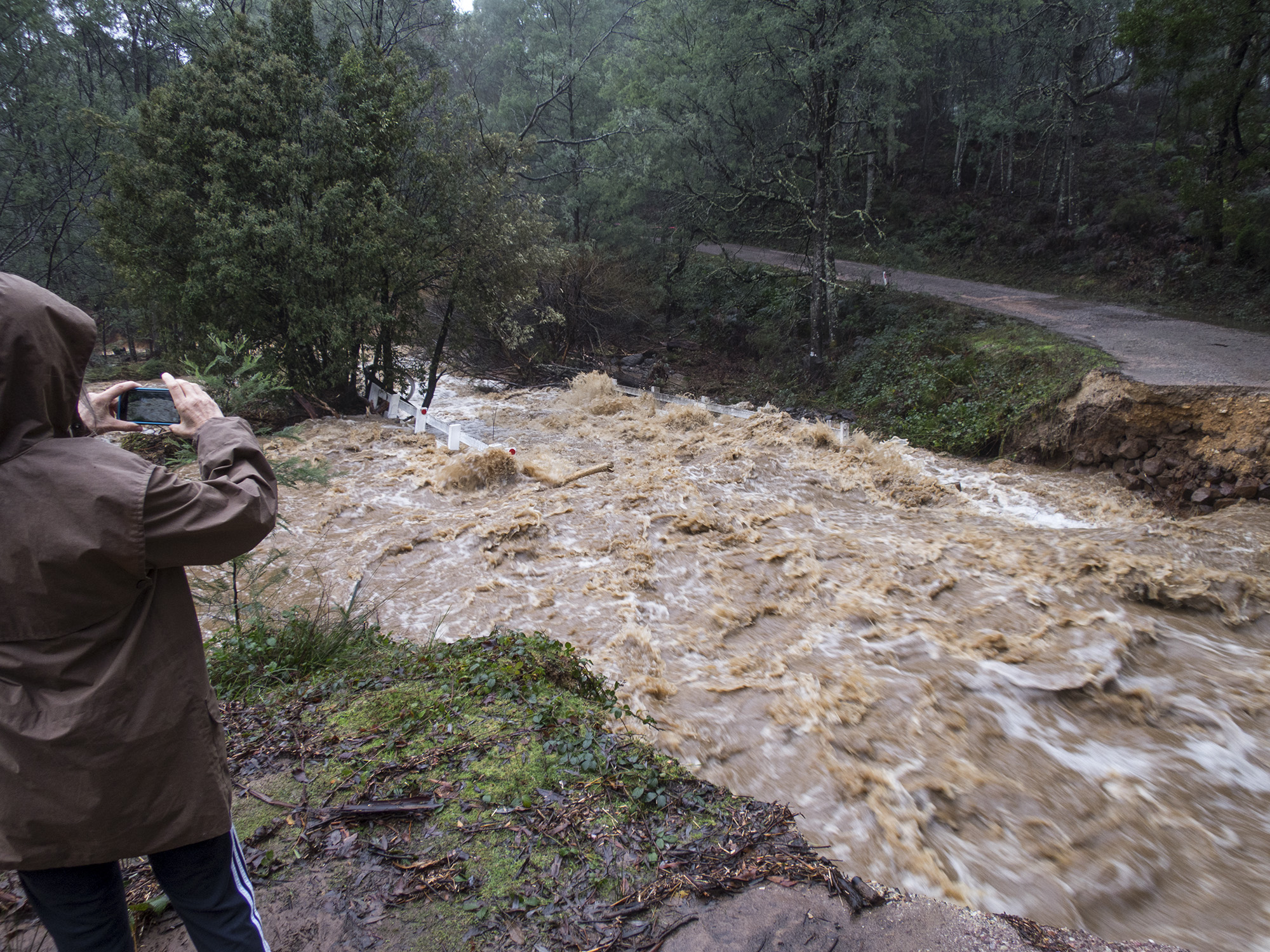
Bridge over Oliver’s Creek washed out. You can just see what is left of the bridge downstream a bit.
So we packed what we could on Tuesday evening, separating out essentials (hand luggage) and packing the larger items into our car to remain at Lorinna indefinitely. We set our alarm for 6.00 Wednesday morning and got to the boat launching ramp by 7 am, where Trevor met us with the punt. It was freezing and just starting to get light. Trevor had been worried about the punt becoming beached during the night because of the rapid reduction in the water level. He had set it out a fair way on the water the night before with a line, and it was just OK and floating.
We set out with the punt, and along a bit further we picked up Bob Robinson who was on the other side of the washed out bridge so was unable to get to the boat launching ramp. He brought on board a huge stash of empty fuel cans to be filled up in Sheffield for the Valley people to use in their generators etc.
Trevor piloted the punt very carefully along a lake filled with floating logs and debris. A couple of times he had to slow right down to dislodge some “hitchhikers”. We felt very safe because of his obvious experience.
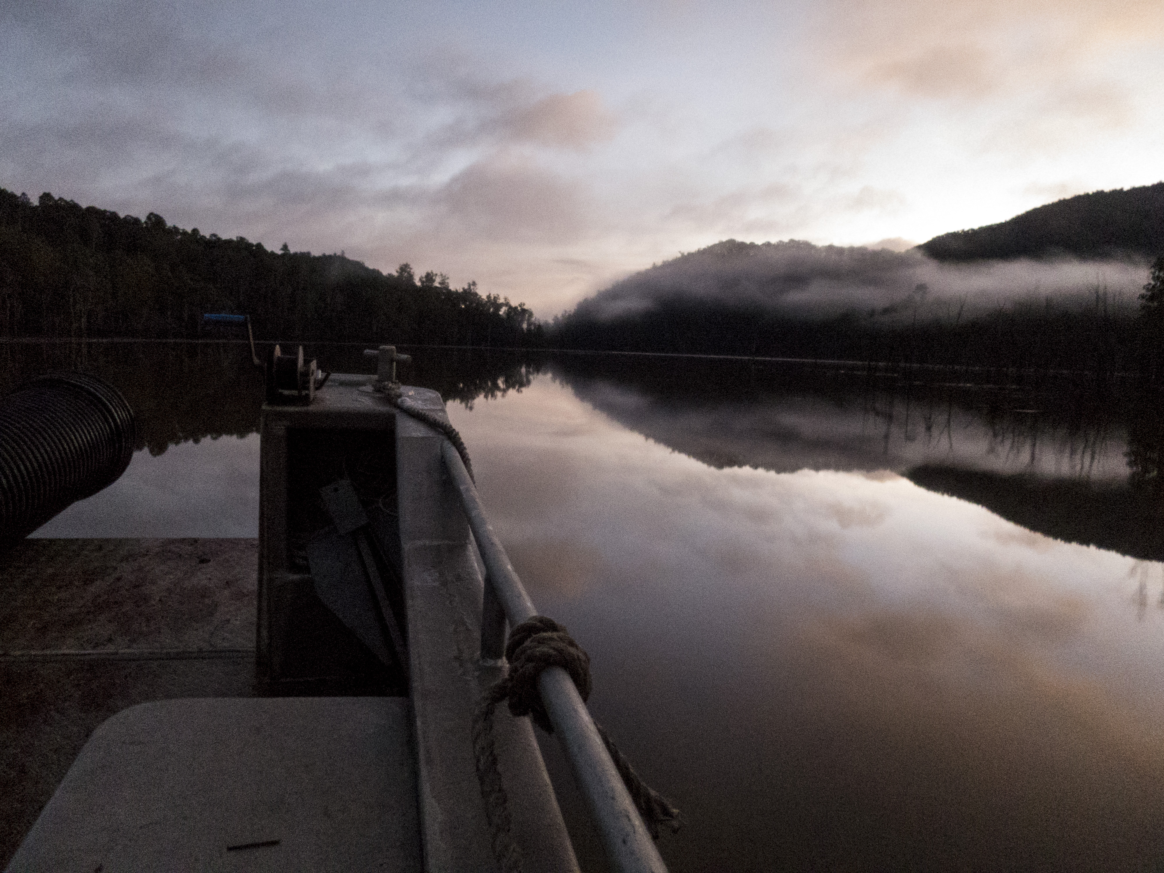
On the punt
We arrived at Cethana dam at around 7.30 am. John had had the foresight to pack some firelighters and matches, so after looking around the dam area we wandered up the road to find a spot to light a fire and settle down to wait for Roger.
It was great at this stage to actually have some mobile coverage. We were able to contact Roger and heard from him that he was having some difficulty getting through to the dam, because of widespread flooding on other roads. Finally he had to go via Devonport, from which one road was still open to Sheffield.
After about 4 hours waiting by the fire John and I were rapidly growing exhausted. We kept ourselves busy finding sticks to keep the fire going, even though by this time it was not so cold.
I need not tell you that we were extremely relieved to finally see Roger arrive around midday, as there had been some question as to whether he would be able to get to us that day at all due to widespread flooding and numerous blocked roads.
When we finally drove into Sheffield, it was wonderful to see civilisation again, and have a lovely espresso before the long drive back down to Hobart.
We are hoping it will not be too many weeks before we are reunited with our trusty Jimny.
THANK YOU
We can’t say thank you enough to all of the people who helped us:
- Our caretaker for his endless energy in supporting us through the uncertainty, giving us latest news and updates, looking after our car, organising our evacuation out, etc. etc.
- Roger for driving 11 hours and 750 ks in one day to get us back to Hobart
- Trevor the punt operator for his expertise and good humour
- The two drivers who passed by our little camp fire and checked to make sure we were OK
- The girl in the café at Sheffield who gave us a discount on our espressos
- Our kids and our friends who expressed concerns and gave offers of assistance
Maria and John Grist
Roger’s report the day after evacuating Maria and John:
The whole of the Lorinna Valley is now cut off by a collapse in the only road in and out. The evacuation plan was for Maria and John to go with Trevor on the punt to the boat ramp at the Cethana dam face and I would pick them up from there.The access is off the Cradle Mountain Rd. I had kept an eye on the Police road closures posted on a continually updated site and even though the Liena Rd was closed at the turnoff to King Soloman’s cave, the turnoff road we normally take to Dorje Ling Retreat Centre (Oliver’s Rd over echo bridge up to Lemonthyme Rd) was consistently showing as not closed. I left Hobart at 6am and just squeaked past Longford at the peak of the rising flood. The water was lapping the edge of the highway and it felt like I was driving on top of a huge lake. From Mole Creek there were a couple of places where the road had half collapsed but was still just passable. (see pic) But on arrival at the turnoff to Oliver’s Rd, both roads were closed. After talking to a couple of Liena locals and some Mersey council workers, it was clear that that road would be unpassable for a long time.
What to do? I wasn’t sure whether I could get to the pick-up point so what would John and Maria do if I couldn’t get there? Reports were showing closures on Claude Rd.and problems getting to and from SheffieId. I drove back to Deloraine and when I had reception I called the land-line on the diving barge, which our retreat centre caretaker had given me. The guy I spoke to said that they had been getting through to Sheffield and there was only one way to get to Sheffield and that was from Devonport and gave me directions for the correct road (not the main one which was closed in one place)
That all worked well (saved by that phone no.or I wouldn’t have known the only route through!) and I eventually arrived at Cethana dam and found John and Maria sitting by a warming fire. The diversion back to Deloraine, then to Devonport and Sheffield took an extra hour, but so glad to finally pick them up. We had to go the same way back and after a total of 11 hours driving and 750 km we arrived back in Hobart just on dark.
Roger McLennan
Below: Video by Maria and John Grist